We use cookies to ensure our site functions properly and to store limited information about your usage. You may give or withdraw consent at any time. To find out more, read our privacy policy and cookie policy.
Manage Cookies
A cookie is information stored on your computer by a website you visit. Cookies often store your settings for a website, such as your preferred language or location. This allows the site to present you with information customized to fit your needs. As per the GDPR law, companies need to get your explicit approval to collect your data. Some of these cookies are ‘strictly necessary’ to provide the basic functions of the website and can not be turned off, while others if present, have the option of being turned off. Learn more about our Privacy and Cookie policies. These can be managed also from our cookie policy page.
Strictly necessary cookies(always on):
Necessary for enabling core functionality. The website cannot function properly without these cookies. This cannot be turned off. e.g. Sign in, Language
Analytics cookies:
Analytical cookies help us to analyse user behaviour, mainly to see if the users are able to find and act on things that they are looking for. They allow us to recognise and count the number of visitors and to see how visitors move around our website when they are using it. Tools used: Google Analytics
Share HSR Next - Moving Hamilton Forward on FacebookShare HSR Next - Moving Hamilton Forward on X (formerly Twitter)Share HSR Next - Moving Hamilton Forward on LinkedinEmail HSR Next - Moving Hamilton Forward link
HSR is moving Hamilton forward with HSR Next, the largest transformation of the city’s transit network in decades. Beginning in fall 2027, HSR plans to roll out the first phase of network improvements designed to make transit faster, more connected and more reliable across Hamilton.
Proposed myRide On-Demand Zone Expansion
HSR is exploring opportunities to expand myRide On-Demand transit to customers in Mount Hope and Stoney Creek, replacing the current Trans-Cab service. This proposal is part of the HSR Next annual service plan, beginning in fall 2027, pending Council approval. HSR's myRide On-Demand is a “stop-to-stop” service that dynamically adjusts the route as customers request to be picked up. Help us understand what matters most to you by sharing feedback on:
myRide service area boundaries
myRide stop locations
Important destinations in the new myRide zones
How you will connect to HSR fixed routes and GO Transit
Your input will help shape future myRide On-Demand service in your area.
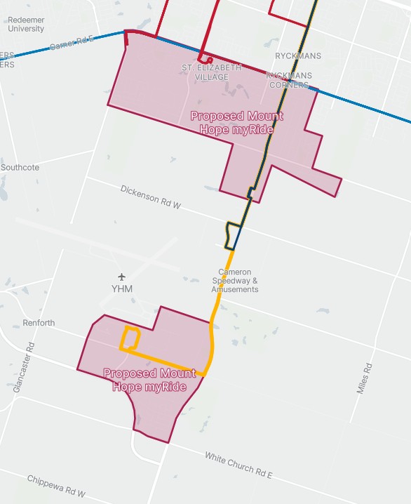
Mount Hope The Mount Hope zone is divided between two areas. The north area is bordered by Glancaster Road to the west; Rymal Road to the north; and Twenty Road to the south. The eastern border follows Springside Drive, Alderlea Avenue and Greti Drive. Connections to routes 20 A-Line and 27 Upper James are provided along Upper James Street. HSR’s Mountain Transit Centre, 2200 Upper James Street, is included in this zone.
The south area is bordered by Upper James Street to the east and includes the airport parking lot and employment area, the Mohawk College campus and KF Aerospace on Airport Road, and the residential neighbourhood running along the west side of Upper James Street. Connections to routes 20 A-Line and 27 Upper James are provided along Upper James Street.
There is no connection between the north and south myRide service zones in Mount Hope. Trips between zones will need to be taken on HSR’s conventional service.
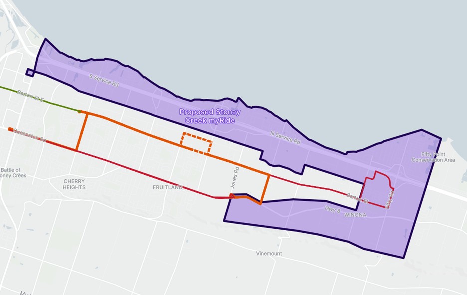
Stoney Creek The Stoney Creek zone is bordered by Centennial Parkway North to the west and runs parallel to the QEW, capturing employment and residential areas to the north and south of the highway. The northern border is Lake Ontario, and the southern border runs parallel to the CN mainline rail corridor. The zone extends towards the escarpment, east of Winona Road, capturing the areas along Highway 8. The service area ends at the eastern boundary between the City of Hamilton and Niagara Region. Confederation GO Station is included in this myRide zone, and the future Stoney Creek Gateway terminal will be included.
Past Engagements
Proposed Fall 2027 Hub-to-Hub Transit Service Changes
As part of the first year of HSR Next, we are reviewing several proposed service changes, including:
Route changes on Route 27 Upper James in the downtown area
Updates in the east-west service corridors on Hamilton Mountain
Several routes will be retired, and new routes will be introduced
Increased evening service on Route 20 A-Line
These proposed changes are part of a broader shift from a downtown-focused network to a hub-to-hub transit system, improving cross-city travel and preparing the network for future express transit connections.
HSR is moving Hamilton forward with HSR Next, the largest transformation of the city’s transit network in decades. Beginning in fall 2027, HSR plans to roll out the first phase of network improvements designed to make transit faster, more connected and more reliable across Hamilton.
Proposed myRide On-Demand Zone Expansion
HSR is exploring opportunities to expand myRide On-Demand transit to customers in Mount Hope and Stoney Creek, replacing the current Trans-Cab service. This proposal is part of the HSR Next annual service plan, beginning in fall 2027, pending Council approval. HSR's myRide On-Demand is a “stop-to-stop” service that dynamically adjusts the route as customers request to be picked up. Help us understand what matters most to you by sharing feedback on:
myRide service area boundaries
myRide stop locations
Important destinations in the new myRide zones
How you will connect to HSR fixed routes and GO Transit
Your input will help shape future myRide On-Demand service in your area.
Mount Hope The Mount Hope zone is divided between two areas. The north area is bordered by Glancaster Road to the west; Rymal Road to the north; and Twenty Road to the south. The eastern border follows Springside Drive, Alderlea Avenue and Greti Drive. Connections to routes 20 A-Line and 27 Upper James are provided along Upper James Street. HSR’s Mountain Transit Centre, 2200 Upper James Street, is included in this zone.
The south area is bordered by Upper James Street to the east and includes the airport parking lot and employment area, the Mohawk College campus and KF Aerospace on Airport Road, and the residential neighbourhood running along the west side of Upper James Street. Connections to routes 20 A-Line and 27 Upper James are provided along Upper James Street.
There is no connection between the north and south myRide service zones in Mount Hope. Trips between zones will need to be taken on HSR’s conventional service.
Stoney Creek The Stoney Creek zone is bordered by Centennial Parkway North to the west and runs parallel to the QEW, capturing employment and residential areas to the north and south of the highway. The northern border is Lake Ontario, and the southern border runs parallel to the CN mainline rail corridor. The zone extends towards the escarpment, east of Winona Road, capturing the areas along Highway 8. The service area ends at the eastern boundary between the City of Hamilton and Niagara Region. Confederation GO Station is included in this myRide zone, and the future Stoney Creek Gateway terminal will be included.
Past Engagements
Proposed Fall 2027 Hub-to-Hub Transit Service Changes
As part of the first year of HSR Next, we are reviewing several proposed service changes, including:
Route changes on Route 27 Upper James in the downtown area
Updates in the east-west service corridors on Hamilton Mountain
Several routes will be retired, and new routes will be introduced
Increased evening service on Route 20 A-Line
These proposed changes are part of a broader shift from a downtown-focused network to a hub-to-hub transit system, improving cross-city travel and preparing the network for future express transit connections.
HSR Next - Moving Hamilton Forward has finished this stage
Public consultation opens with project information, survey, map, and in person sessions.
May 2026 Proposed Hub-to-Hub Transit Service Changes
July 2026 my-Ride On-Demand Zone Expansion
Feedback under review
HSR Next - Moving Hamilton Forward is currently at this stage
Feedback is reviewed by the Strategy and Planning team to help inform recommendations.
Report to Council & Community
this is an upcoming stage for HSR Next - Moving Hamilton Forward
Feedback collected through engagement is incorporated into the annual service planning report for Council approval and supported through the City’s budget process.