
FAQs
- Municipal Drain Study: This focuses on determining a solution to the flooding issue from outside of the public right-of-way through the works covered under the Ontario Drainage Act (1990).
- Municipal Class Environmental Assessment (MCEA): This study will address the issues (including road flooding) from within the public right-of-way along Safari Road.
What is a Municipal Class Environmental Assessment?
Municipal Class Environmental Assessment (MCEA) studies are undertaken for municipal road, water, wastewater and transit construction projects to ensure all reasonable alternative are considered and that the preferred solution will have minimal impacts to the natural, cultural, social and economic environments. The MCEA process ensures that the public and key interested parties are consulted throughout the planning process and feedback received is taken into consideration in the decision-making process.
What is a Schedule ‘B’ Municipal Class Environmental Assessment Undertaking?
This study is a Schedule ‘B’ Class Environmental Assessment (Class EA), which requires the completion of Phase 1 and 2 of the MCEA planning process. This includes identifying the Problem or Opportunity, Developing Alternative Solutions, selecting a Preferred Solution to address the problem and opportunities, and preparing a Project File Report, which documents the planning process undertaken. Learn more about the MCEA process at: https://municipalclassea.ca/manual/
What is the City doing to address the flooding on Safari Road?
There are two studies that are currently underway:
Note: These studies are being completed as separate assignments; however the findings of each study will be shared so that the recommendations complement each other.
When is the Safari Road Class EA study commencing?
The study commenced in early Summer 2024.
What is the estimated time for completion of the Safari Road Class EA?
It is estimated that the Safari Road Class EA will be completed in the spring of 2026. We will provide updates as the project progresses.
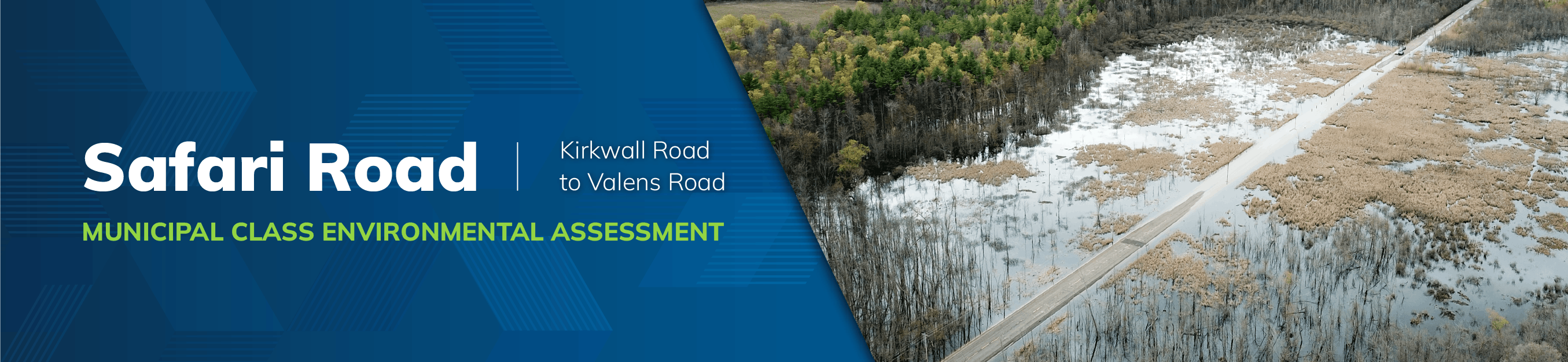
What part of Safari Road are you studying as part of this Municipal Class Environmental Assessment study?
The study area includes lands within the Safari Road right-of-way from Kirkwall Road to Valens Road.
What is causing the flooding on Safari Road?
A portion of the study area lies within a designated Provincially Significant Wetland (PSW), known as the Sheffield Rockton PSW Complex that is part of a larger and interconnected complex of regenerating natural areas known as the Hyde-Rockton-Beverley Complex (Environmentally Significant Area #22 in the City of Hamilton Official Plan). The flooding on Safari Road is due to the disruption of natural flow of an adjacent watercourse and the overall surface water drainage in the area.
As part of the Safari Road Class EA, a hydrological and drainage study will be undertaken to support development of alternative solutions for the flooding issue, focusing specifically along the public right-of-way.
How will my comments be incorporated in the study?
Input from the public, stakeholders and technical agencies is essential. As such, comments from the public are encouraged to help the study constructively move forward to address the flooding and drainage issues at Safari Road. The comments received during the public information centers (PICs) will be reviewed for consideration in the project, and ultimately in determining the preferred solution.
How can residents stay informed and involved?
Residents are encouraged to regularly check the Engage Hamilton and project websites for updates, attend public meetings and participate in community engagement. The feedback from the community is vital to the success of this project.
You may also contact the city project manager at any time should you have any questions.
What is the preferred solution?
Raising the road is recommended as the preferred solution as it addresses the primary problems and opportunities identified including: flooding and safety for road users.
This solution maintains an efficient route for trucks, restores access for emergency vehicles, postal services and school buses for local residents and; improves east-west connectivity for walking and cycling.
What will happen to private driveways if Safari Road is raised?
Access will remain. Driveways will be adjusted to align with the raised road profile on Safari Road.
Why is permanently closing Safari Road not being recommended?
Permanently closing the road is not recommended because it does not adequately address the problems identified in the area. It is also the most expensive option due to required improvements to adjacent corridors and property acquisition.
Why not make the current signed detour route the permanent solution?
The current detour was only meant as a temporary solution. If made permanent, significant upgrades are required to the detour roads. Improving Safari Road offers a more direct, reliable and cost-effective route for trucks and other road users.
How will impacts to the existing wetland from raising the road be mitigated?
Impacts will be mitigated at two stages. First, the design of the road will take up as little “footprint” as is necessary. Secondly, construction will be planned and executed to prevent excessive disturbance of adjacent areas. Measures will also be put in place to control erosion and silt migration from disturbed areas.
Will habitat fragmentation associated with the road be mitigated?
Wildlife crossings will be included in the design as warranted. In addition, a fence of sufficient height is proposed to function as a barrier to guide wildlife to the crossings. These measures will provide continuity for wildlife movements and reduce road-related mortality.